Mobile: 07931 940277
07917 573772
Tel: 02392 528019
Tidal Curve Construction
Tidal Curves are very useful tools in our armoury and help us to navigate safely in waters of varying depths. As part of our morning boat preparation this is on our list of things to do before leaving. Portsmouth is the main standard port in The Solent so we have a Portsmouth Tidal Curve constructed every morning for reference. What do we need:
- A Portsmouth Curve (we have enlarged laminated curves on board our vessels)
- The almanac
- Pencil
- Straight edged instrument
The construction is pretty straight forward, we also have a short video covering this on our YouTube channel
Process:
- Find the tides for the day
- Fill the times in at the bottom of the curve (use the High Water [HW] that is relevant to your period of travel)
- Mark the height of HW on the top line
- Mark the height of low water (LW) on the bottom line - if you are travelling before the HW time you should use the LW height before HW, if you are travelling after the HW time you should use the LW height after HW
- Draw a line connecting the HW and LW heights
- Work out whether you are in neaps or springs - this can either be done by working out the range (the difference between HW and LW) or if the date for the day is in blue this will denote neaps or red for springs. This will dictate which colour line you use on the curve
- You can then use the curve to work out the height of tide at a specific time or what time you will have an amount of tide you need
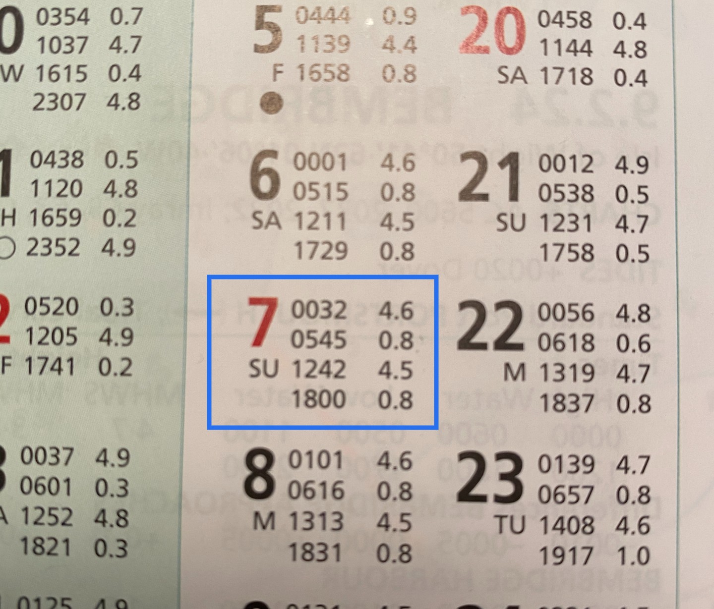
Find your day of travel in the Almanac
Find the day for the relevant port. On this occasion I have chosen 7th April.
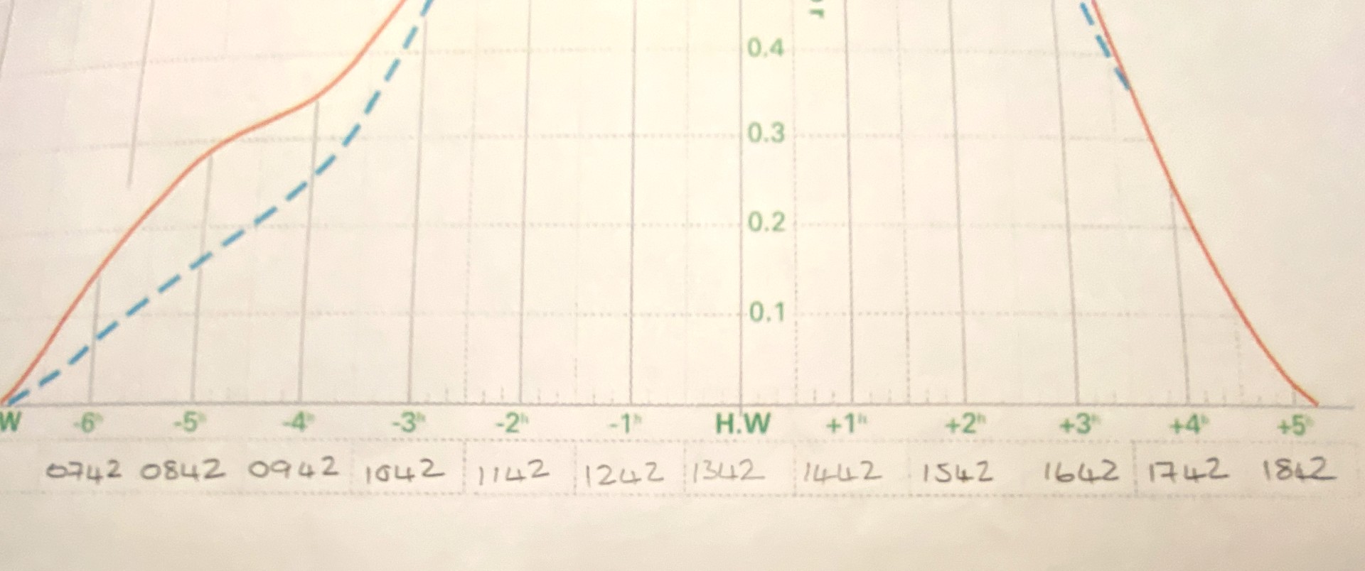
Complete the times on the curve
Remember to add an hour to any unshaded areas. (DST / BST)
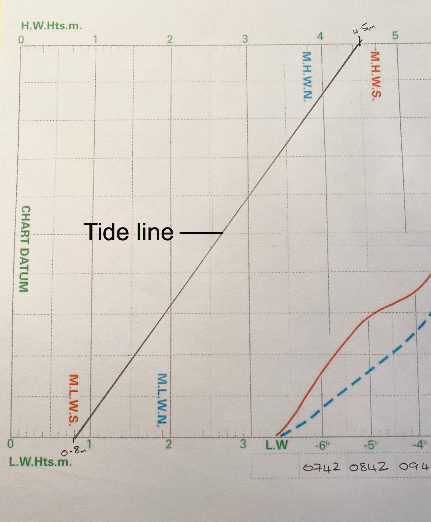
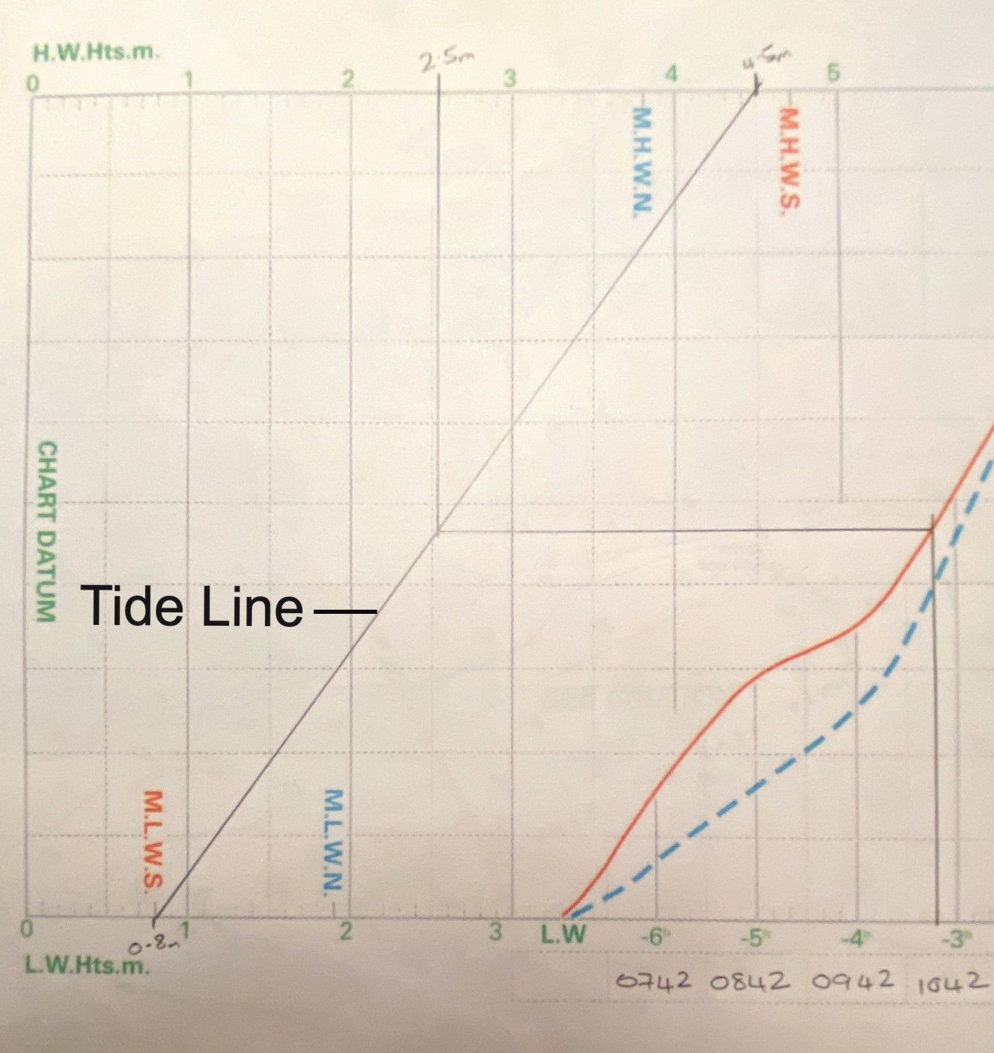
Complete the heights on the curve
Mark the height of HW along the top scale and the height of LW along the bottom scale.Join these two together, this will give you a diagonal tide line.
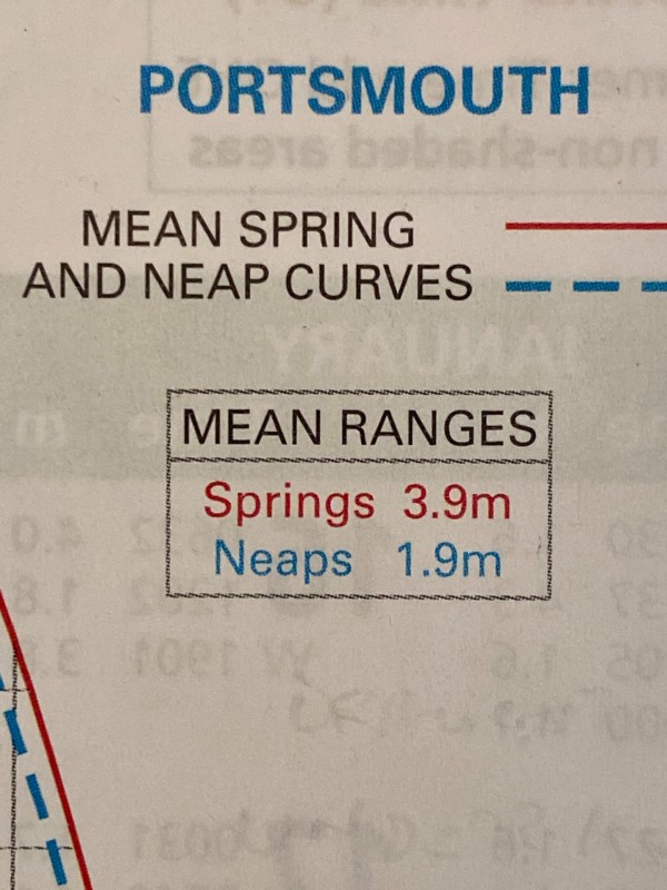
Is it neaps or springs?
The best way to do this is to work out the range for the day, take the low water height from the high water height. In this instance we have a range of 3.7m we the compare it with the mean ranges in the port you are using. 3.7m is very close to the mean range for springs at Portsmouth of 3.9m so we will go with springs. Alternatively as the almanac says 'dates in red are springs / dates in blue are neaps.
What is the height of tide at a certain time
Find the time you require along the time scale, draw a line up to the red or blue line on the curve depending whether it is neaps or springs. If the range is in the middle then you take your line in between the neap and spring line where you can. I have chosen to find the height of tide in this example at 1030
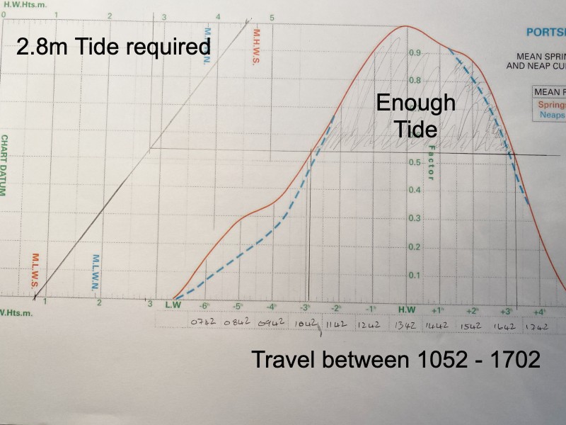
When will I have enough tide
Find the height of tide you need along the high or low water scale, draw the line down or up depending which scale you have used until it intersects your tide line then draw a line from the intersection all the way across your curve. You can then work out the period of time you will have the amount of tide (or more) that you need.
We hope that was useful, take a look at our other 'how to' blogs and don't forget to take a look at our video Tidal Curve Construction
About the author

Comments
By accepting you will be accessing a service provided by a third-party external to https://www.nomadsailing.co.uk/