Mobile: 07931 940277
07917 573772
Tel: 02392 528019
Iles Chausey - a pilotage dream
2020 has been a year unlike any other and not in a good way, that said I was lucky enough to get the opportunity in August, between lockdowns and the ever changing Tier system, to visit Iles Chausey for the first time. Located to the north east of St Malo on first glance at the chart Iles Chausey looks like a pile of rocks marked with plethora of Cardinal Marks and indeed it is just that, although all the cardinals are very gladly noted. On closer examination Iles Chausey gives the opportunity for some delightful and challenging pilotage 😉
So here it is, the amazing Iles Chausey as we identified it on the chart. We were up in Dielette and having had two pretty long days were trying to find somewhere to hole up for a night before the final push to St Malo. In addition we had very light winds forecast and the thought of motoring all the way to St Malo did not fill us with deep joy. Thankfully with plenty of daylight hours in August and a very early start we did manage to make Iles Chausey by dusk. Given the very windless passage there was plenty of time to take a look at the pilotage en route.
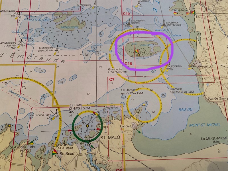
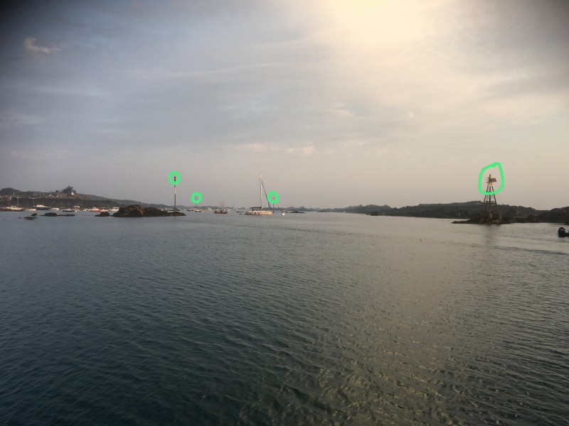
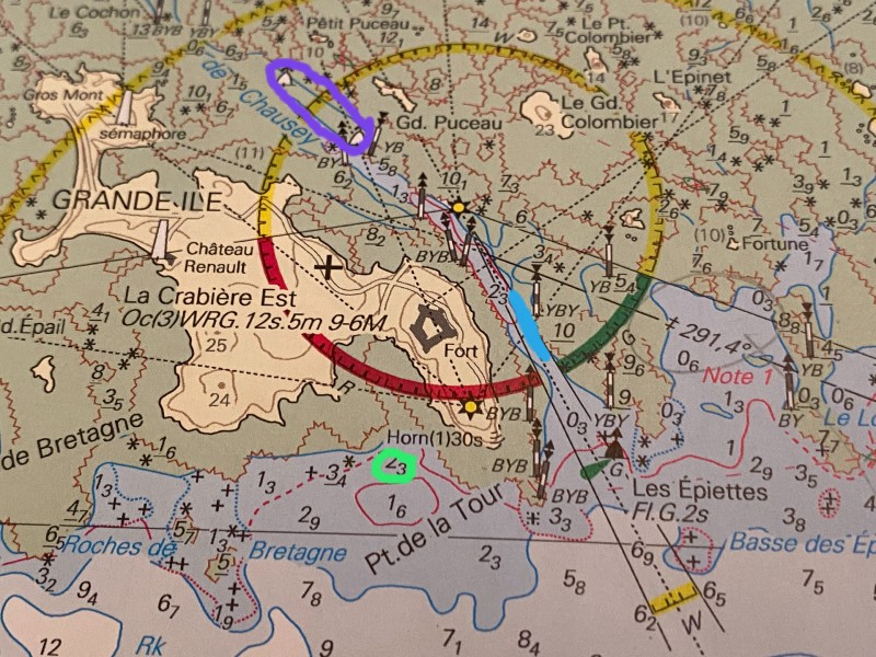
The almanac was our first point of call followed by Mr Cunliffe's Shell Channel Pilot. Iles Chausey is a secondary port to St Malo but lying quite close the differences were negligible, all corrections for Iles Chausey showed a + against the St Malo tidal heights. The time differences were the same for all times of high water and all times of low water so no complicated calculations were required. As can be seen, the entrance to the channel is clearly marked for both day and night entry with a lit green lateral mark and a sectored white light to see us in at dusk, when we arrived. There are also plenty of unlit cardinal marks for day time navigation (circled in green on the photo above).
Having read the Channel Pilot there appeared to be some visitors mooring buoys up the main channel next to the white buoy shown at the top of the chart adjacent and covered by the purple markings on the chart below. The range of tide at Iles Chausey during springs is 11.1m and during neaps 4.8m. We arrived on 10th August and were firmly in neap tides with a low water of 4.2m
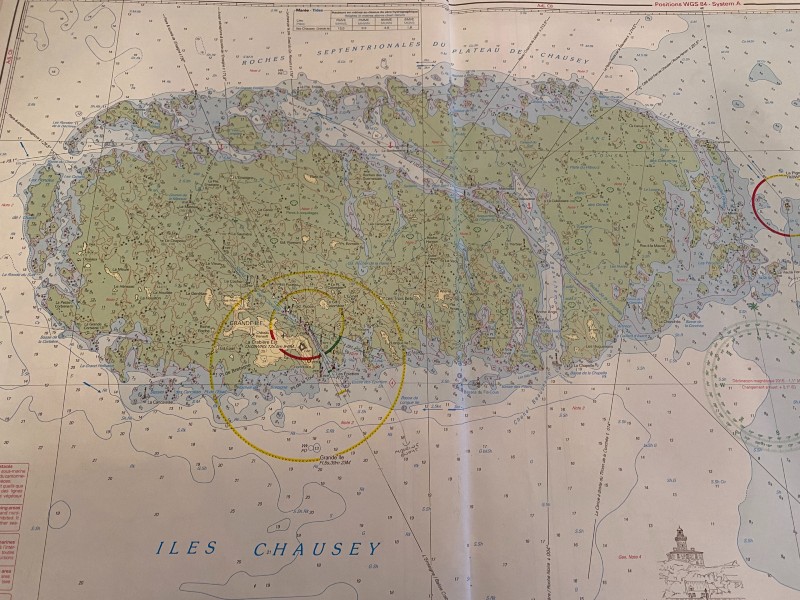
Having worked out the that we had 4.7m of tide which would fall to 4.2m within the hour we proceeded up the main channel looking for the visitors mooring buoys. Now everywhere we had been so far on our little trip had been pretty much deserted so you can imagine our surprise and disappointment to find the moorings absolutely rammed. Due to the width of the channel here boats were attached to a buoy fore and aft to stop them drifting into the channel when the tide turned, every buoy had at least 3 boats on it 😳. By the time we had made it this far it was pretty dark and the parties had begun. On the way into the main channel we had noticed a few other mooring buoys which were empty (marked in blue on the adjacent chart), whilst we figured these were probably not visitors moorings there was no one on them so we thought we would take our chances.
Following a number of attempts in the dark we managed to hook the line and secure ourselves for the evening, the galley crew got on the job and produced a top meal in no time which was admirably accompanied by a couple of bottles of French wine.
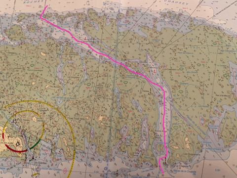
Now for those of you wondering what the little green circle is on the chart above, this is where we anchored on our second visit to Iles Chausey, yes, we came back !! Following a fab couple of days in St Malo we returned to Iles Chausey, again we tried to get on the visitors mooring buoys but there was no room at the inn. Having been spoken to firmly by a local french ferry man we were told in no uncertain terms that we could not use the mooring buoys we had previously picked up so we elected to anchor. Now I have no problem with anchoring, the conditions were very benign, I have a problem with the fact that due to our Solent based activities and having a manual anchor we do not carry the 60m of chain I would have preferred in these circumstances.
To add to the mix some of the crew wanted to swim ashore so we couldn't be too far off. We arrived at the anchorage an hour before high water, we had 9.8 metres of tide which was going to rise by another 0.9m. The fall of tide to low water would be 7.8m (LW 2.9m), our draught is 2.1m and we wanted 1m clearance at LW so ideally we wanted to anchor in 10.9m of water. Unfortunately this took us too far from the shore to allow swimmers to get to shore so we ended up anchoring on the 2.3 datum spot. We chucked out everything we had (30m chain & 30m warp). Note to self - put more chain on for the next trip to these parts
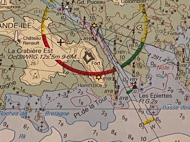
The following day we decided that it might be fun to navigate down the centre of Iles Chausey, whilst there are many navigable channels at the right height of tide, we thought we would start with the one that looked the easiest. So after swims and breakfast were complete we set out. The pink line shows the track we followed (this is not off a chart plotter, but my rather wobbly line put on a photo). I would like at this point to impress you all and say this was done without the use of electronics but I would be lying. I do however think it could be done without the use of electronics and below is how I would do it 😊.
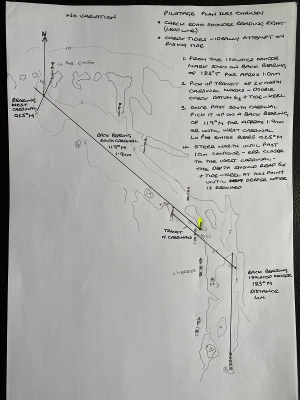
So I start by apologising for my hand writing and make the key notes as follows:
- At the time of writing there is no variation to apply for the area
- Check that the echo sounder is reading correctly (lead line)
- Using back bearings and transits for the majority of the pilotage accounts for any set by the tide
- Starting from the Isolated Danger Mark proceed on a back bearing of 183°M from the IDM for approximately 1nm
- Having passed two East Cardinals to port you should pick up two North cardinals to port
- There is a double check here with datum being 6.2m +tide - keel and also the second East Cardinal should bear 263°M
- With the two North Cardinals in transit the bearing / heading should be 301°M proceed keeping the Cardinals in transit until leaving them both to port
- Once through the narrow gap of the North and South Cardinal pick the South Cardinal up on a back bearing of 119°M for approx. 1.9nm or until the West cardinal La Pte Entree bears 025°
- When La Pte Entree bears 025° turn due North and proceed until past the West Cardinal and into deeper water, pass a few boat lengths from the West Cardinal to starboard to avoid the rocks to port
- The datum through this last section in 5.5m so you could double check you are in the right place adding tide and minus keel (if your echo sounder reads from the bottom of the keel)
About the author

By accepting you will be accessing a service provided by a third-party external to https://www.nomadsailing.co.uk/