Mobile: 07931 940277
07917 573772
Tel: 02392 528019
Pilotage - a few hints for 'would be' Day Skippers
Pilotage - what is it ?
There are numerous definitions, one I particularly like is - 'pilotage is the use of fixed visual references on the ground or sea by means of sight to guide oneself to a destination'.
Certainly in the Solent and around much of the UK coastline there are numerous visual references wherever you may be, for these visual references to be effective we need to work up a pilotage plan so that we can identify what we can see and as a result know the location of our vessel. A pilotage plan will enable us to safely navigate up a river or into a harbour and we have many tools at our disposal to help us work up an effective plan:
- Almanac
- Large scale charts
- Tidal Stream Atlas
- Pilot books
- Nomad course notes (if you have taken one of our classroom courses or are a member of 'Club Nomad')
With the help of the tools at our disposal what are we actually looking for to work up our plan ?
- Identifiable buoys
- Transits (when two objects line up one in front of the other)
- Bearings (using a magnetic compass to identify where we are in relation to a known mark)
- Back bearings (using a magnetic compass to find the bearing to an object behind us or staying on the same magnetic bearing in relation to an object behind us)
- Depth contours (can we follow a line of depth on the seabed using our echo sounder)
- Knowing the height of tide at the time we will be executing our pilotage
- Knowing what the tidal streams will be doing when we are executing our plan
- Finding out if there are any rules specific to the area we are intending to navigate
- Finding out if there is a specific VHF radio channel we should be listening to whilst executing our pilotage
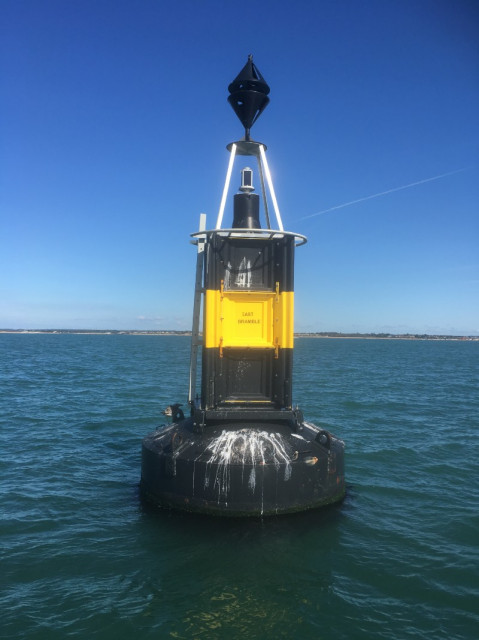
Most buoyage will be either named or numbered, this is East Bramble, an East Cardinal Mark
This is an example of a man made transit, the ball and the stripy Y have been put here specifically to guide boats into Newtown River. If we position our vessel so that the ball sits in the Y we will maintain a safe depth to approach the entrance of the river which is just to the right of this photo. In this photo we are not in the right place yet.
As Benjamin Franklin once said, "If you fail to plan, you are planning to fail." There are many benefits to producing a comprehensive pilotage plan, not least, it means you have looked and written out in detail where you are planning to go and as a result much of it will stay in your mind. My preference is a sketch and that is what I am covering here but there is an alternative called a 'rolling road' which is covered in a separate blog. Many people today rely solely on their GPS chart plotter and whilst having this as a back up may be a comfort there are many things that could go awry:
- They have not necessarily looked ahead at the area being navigated so do not know what to expect
- Power to systems may be lost
- Is the chart on the plotter up to date, a new unidentified buoy may throw you off
- There are some very comprehensive navigation systems out there but does the plotter take into account tidal heights and streams ?
- A chart plotter will not give you rules of entry if there are any nor will it give you VHF channels to listen to if there are any
Let's take Portsmouth, one of the more complex harbours to enter.
Enter your text here ...
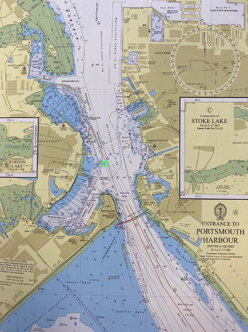
Looking at the initial approach to the harbour entrance, when coming from the west or the south we have two options. We can either use the main transit, the start of which is identified by the pink spot and the two objects (circled in pink) which we are looking to line up - a war memorial and a block of flats behind it. Alternatively we can use the Inner Swashway which I have identified with a pink line. The main transit will ensure we have enough depth of water to approach the main channel no matter what the height of tide. The inner swash requires that we have sufficient tide to cut the corner when coming from the west. I have elected to use the main transit which will bring me towards the main channel to the east of 4 Bar Buoy.
We can see from the adjacent chart that the entrance to the harbour is very narrow for the numerous large vessels entering and leaving. Let's see what the almanac has to tell us, the first thing that becomes clear when looking at the almanac is that there is a Small Boat Channel (SBC) which is mandatory for all craft under 20m LOA (length over all). All craft over this size must get permission from QHM to enter, leave and move within the harbour. The almanac has a small chartlet of the entrance to the harbour showing the SBC.
The rules to leave and enter the harbour as per the almanac:
- Craft may not enter the harbour on the East side of the main channel
- Craft must use engines (if fitted) between No 4 Bar Buoy (circled in green) to Ballast Bn (identified below also in green)
- Once in the harbour if crossing to/from Gunwharf or Camber permission must be obtained from QHM (Queens Harbour Master) and you must cross at 90° to the main channel
- If joining or leaving the SBC via the Inner Swashway BC Outer Bn (circled in yellow) must be left to port
- Keep a listening watch on Ch 11 QHM
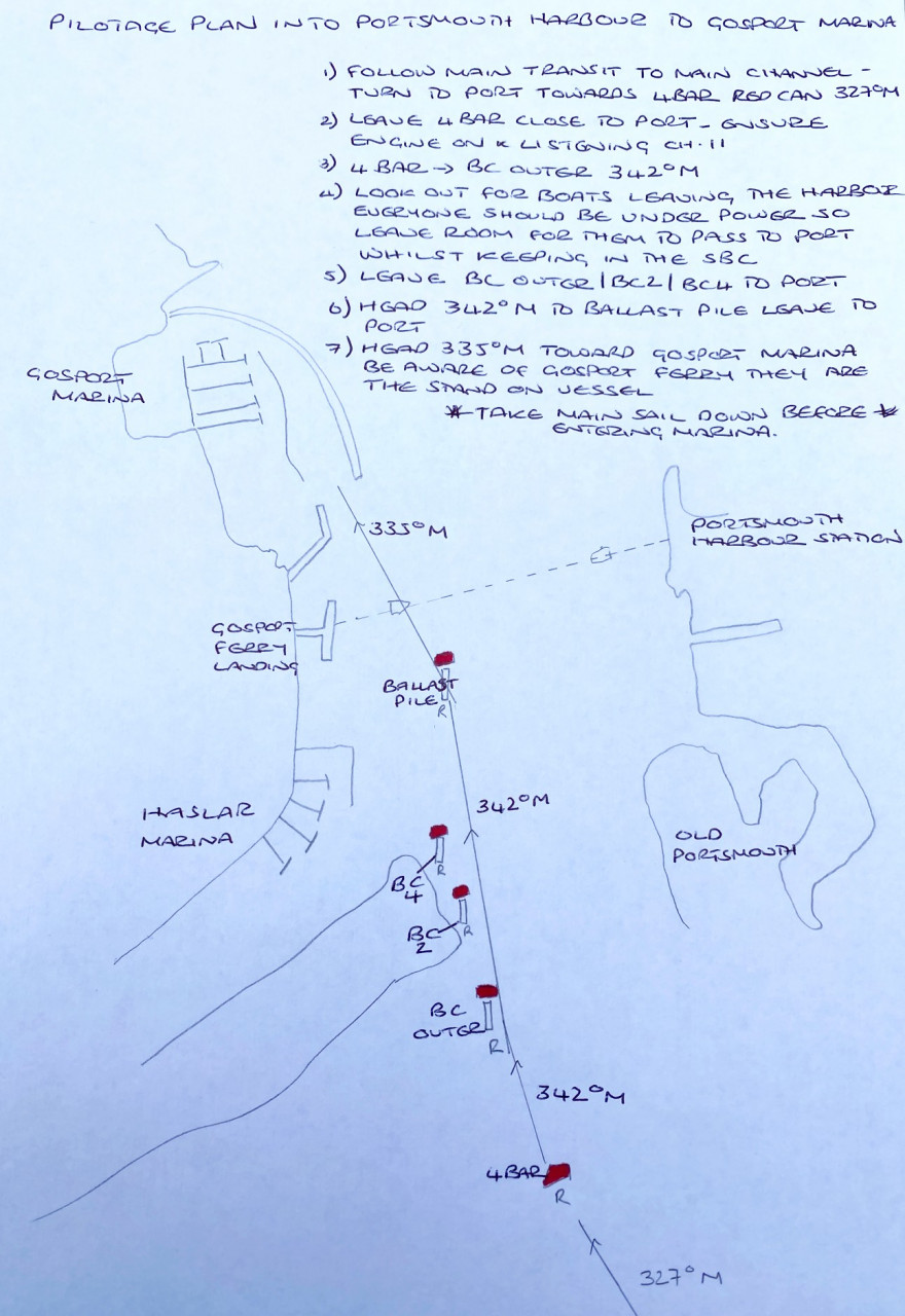
I am certainly no artist but the above is how I like to draw my pilotage plans, I have looked at the almanac in detail and the charts, I have looked at the pilot book to see if there is any further useful information. I have then drawn my plan so much of the information is in my head before we come to execute it. I have put courses between each of the buoys but to be honest (except in thick fog) you will be able to see the next buoy by sight. The other element that could be added here is distance between the main buoys. No charts or books are allowed on deck in case they get blown away or dropped, but you can go down below to check on anything if need be. Very early on in my sailing career I thought it would be a great idea just to photocopy excerpts from the almanac for the ports of entry I needed. I soon learned that it was probably one of the worst ideas I had, without really studying it everything was new at the point of execution and an element of panic ensues. Plan in order to succeed.
How does this work at night - find out more
The Golden Rules of Pilotage:
Never enter into an unfamiliar or uncertain pilotage situation without first having a pilotage plan. If necessary, stop the boat, heave-to, pick up a mooring anchor, or circle before entering so you can prepare the plan. Or, best still, make the plan before you leave!
If at any point you are uncertain of your position go back to your last known mark or stop and work it out.
The pilotage plan allows you to direct the boat from the cockpit rather than the chart-table.
Of course, there are other elements to consider when skippering in pilotage situations – where should the sails be raised/lowered. When do we call for a berthing advice, the preparation of lines/anchor/fenders and other deck work. Soon enough this will all come naturally, but you might consider adding reminders to various sections of the plan to keep on top of it all.
About the author

Comments
By accepting you will be accessing a service provided by a third-party external to https://www.nomadsailing.co.uk/