Mobile: 07931 940277
07917 573772
Tel: 02392 528019
How to work up an Estimated Position
Based on a last known position, the EP is one of the only methods we can use to work out our current position when we haven't got GPS or any visual references. In order to complete, we go back to the last position plotted on the chart and also the information provided by the log. You will need your chart, almanac and plotting instruments to work up an EP.
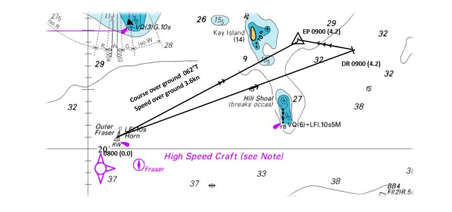
Step by Step Guide to working up an EP
1. Locate your last known position (LKP) and plot this on your chart
2. From your log, plot your Dead Reckoning Position (DR). This is done by converting your compass course steered back to degrees true, plotting this from your LKP and then striking off the distance traveled. This becomes your water track and is annotated with 1 arrow. Ensure you allow for the affect leeway has had on your vessel at this stage, before you plot your water track.
3. We now need to consider how the tide has affected your position. We do this by calculating the direction and rate of the tide, using either the Tidal Diamonds or Tidal Stream Atlas. Remembering to use the correct tidal hour and the standard port in which the diamonds or atlas refer too. The Computation of Rates table should also be referred to if the tidal range is outside that of the printed MHWN or MHWS.
4. Once we have our tidal direction and rate we can plot this from the end of the DR. Again plot the direction of the tide first, followed by its speed. This vector is marked with 3 arrows.
5. Your EP is now complete in its most simple form. The end of the tidal vector is marked with a triangle to denote an Estimated Position and the latitude and longitude can be read and recorded in the log book.
6. If required we are able to interrogate our plot further to work out both our speed and course over ground (COG & SOG). This is done by plotting our ground track, a line from our start position to the end of the tidal vector. If plotted, this line is annotated with 2 arrows to denote our Ground Track.
7. Once plotted you can measure the direction of the Ground Track with a plotter to obtain your Course Over Ground (COG) and the length of this line with your dividers to obtain your Speed Over Ground (SOG).
About the author

Comments
By accepting you will be accessing a service provided by a third-party external to https://www.nomadsailing.co.uk/